Of the 2011 Southern tornado outbreak, April 27th particularly stands out. A total of 199 tornadoes occurred in a 24-hour period leading to 316 fatalities. That not a misprint. 199 tornadoes. What makes the event meteorologically interesting is that tornadoes came from three rounds of weather, each with unique characteristics. Any good, Southern, armchair meteorologist knows the basics of a supercell leading to a tornado. But tornadoes can originate also from quasi-linear convective systems, a only partially understood and complex process. The early morning and midday tornadoes of April 27th arose from just such systems.
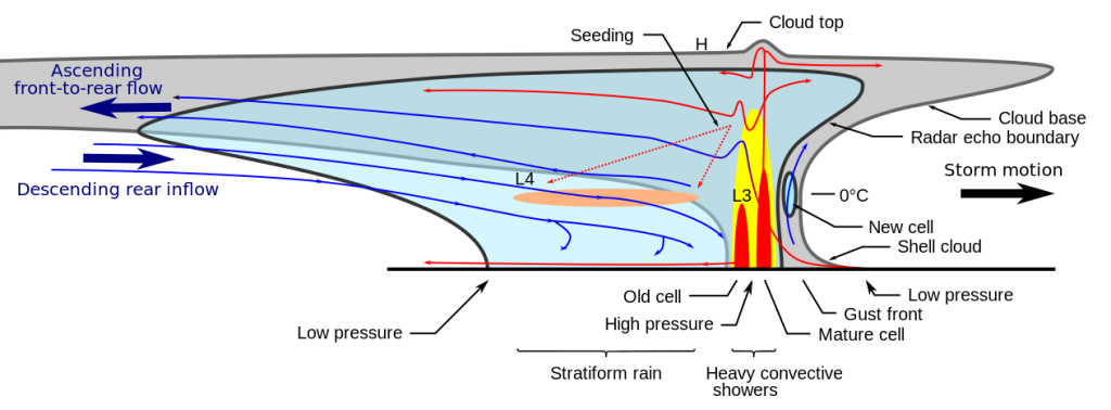
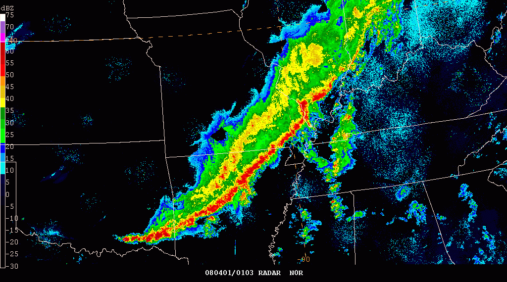
When thunderstorms become organized and active at larger scale, the overall complex is referred to as a mesocscale convective system (MCS). When these MCSs approximate something near linear, typically at the leading edge of a cold front, they are referred to as a quasi-linear convective system (QLCS). You may know this better as a squall line. As many a Southerner knows, the squall line contains heavy rains, hail, frequent lighting, and strong winds. Basically your typical Southern spring day.
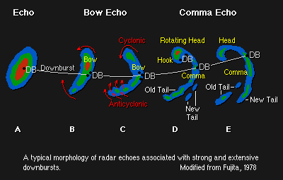
A QLCS can also produce a tornado. The whole process is very complex and only partially understood. The cold front lifts the warm air ahead of it forcibly forming the rain line. The rain cools the air causing the air to sink, called a cold pool, which produces strong winds. These winds rushing out causing the squall line to bow.
Ahead of the storm the cold and dense winds force the warmer air to loft. As these winds “empty” the space behind the bow, a low-pressure area is created. This low-pressure area is filled in by drier air above the storm. This movement continues to accelerates the whole process. A rear-inflow jet (RIJ) forms caused by the elevated area of low pressure caused by a tilted updraft over top of the cold pool.
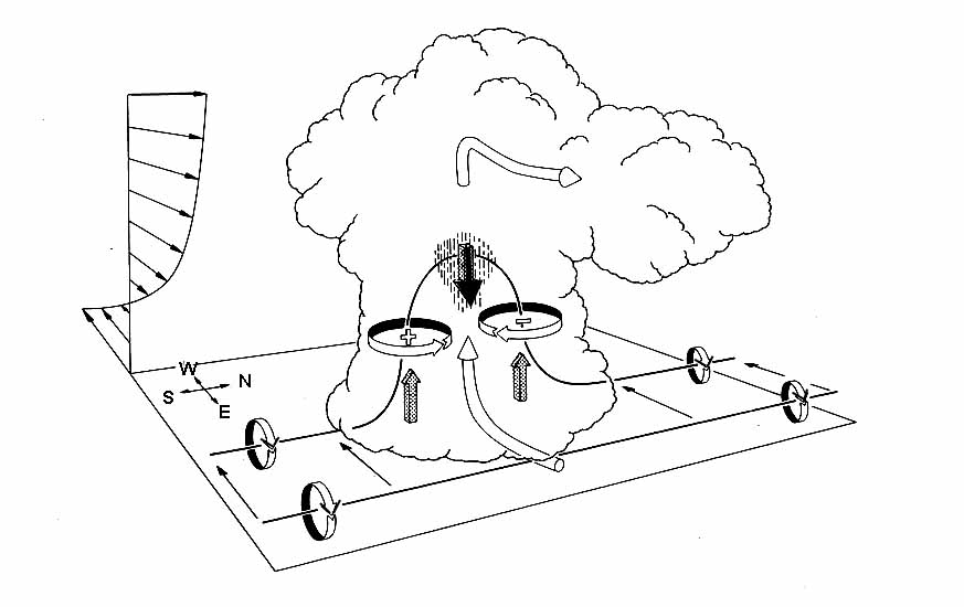
The bookend circulation at the tips of the bow echo is caused by differences air density due to temperature and pressure, i.e. cold dense air sinks and warm light air rises. This vertical air movement causes horizontal rotation. Imagine taking a pool noodle, turn it on its axis, and bend it into an arch.
The circulation occurring at the northern part of the bow is amplified due to Coriolis effects. Interestingly despite the significant rotation, not all QLCS tornadoes are produced in bookend vortices. In fact, most form in smaller-scale vortices at the leading edge of a QLCS.
 In the South a significant number of tornadoes can develop from QLCSs. In one study nearly 55% of the tornadoes in Mississippi and Tennessee over a 5-year period developed from QLCSs. QLCS tornadoes are unlike supercell tornadoes. They both form and dissipate quickly and initiate below the radar detection heights. This combinations of factors make it difficult to warn people of a QLCS tornado. Typically by the time the warning is issued… the tornado is already gone. The fact that more QLCS tornadoes occur during the late night/early morning hours make this lack of warning even more concerning.
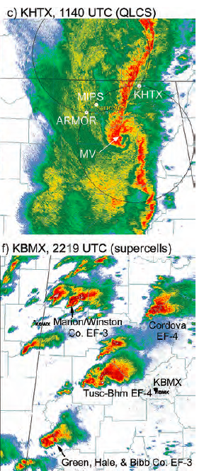
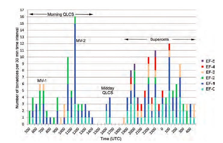 Luckily, QLCSs do not often form larger tornadoes. Rarely, however, QLCS spun tornadoes can reach EF2-3. This is exactly what happened on the April 27, 2011 (see figure above from Knupp et al 2014). The first 76 tornadoes of the day developed from a strong MCS that developed in Arkansas, grew stronger in Mississippi, and evolved into a QLCS in Alabama in the early morning. In the mid-day a second QLCS developed, producing 7 weak tornadoes. The earlier QLCS tornadoes caused multiple local power outages across Alabama. This reduced the possibility of warnings, as electricity is needed for sirens, radio, and television. The afternoon saw the development of supercells that spawned the largest tornadoes of the April 27th outbreak. Many people never received the warning.

